|
What tools and methods do scientists
use to collect data? We have described the ones we will be using below.
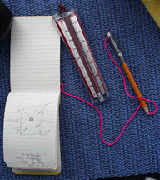
Does it surprise you that sometimes scientists just use pencil and paper?
Residency Scan
How can you tell how many dolphins are in any given area? Researchers
use a method called a residency scan.
A residency scan is where we observe a particular location over a period
of time to determine how many dolphins are in the area. The boat stays
in one location to do this so that the only variables we are looking
at is the time of day, the weather and any human activity in the observation
area. With this information Tamara eventually can answer the following
questions:
Is there anything special about the area we are observing
that would attract dolphins?
Is there a change in the number of dolphins in the area over the
course of a day? Month? Season?
Do both species of dolphins appear in equal numbers and at the same
time or does one species dominate and if so is this related to the
time of day?
Lastly, what happens when humans enter the observation area?
The areas were we will be doing residency scans are at the confluence
of two rivers. Our first residency scan was at the confluence of the
Yanayacu and Marañon rivers. Tamara has noticed over the course
of her study that both species of dolphins tend to congregate in these
areas. The reason why is still not known.
Yanayacu means "blackwater" in Quechua.
There are three types of water found in the Amazon river basin. They
are blackwater, whitewater, and clearwater. Blackwater is the run-off
from the forest floor. Blackwater is sort of a natural "tea." It is
dark in color because it contains tannic acid from all the plants in
the forest. Whitewater is the nutrient-rich water which runs through
the middle of the Amazon in the strong current and comes from high in
the mountains. The water doesn't look white -- like rapids do -- but
muddy. Clearwater is transparent but not particularly nutrient-rich.
While it may seem simple to count animals in the wild, it requires
a lot of patience and careful observation. We practiced for a few hours
before we began the actual residency scans.
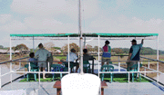
 To
do the scans we work in teams of two for one-hour periods, and then
we rotate teams. Each team of two people is responsible for observing
one area of the river. Each team has a spotter and a recorder. The spotter
calls out every time he or she sees a dolphin surface and whether or
not it is a tucuxi or a boto. The recorder then writes down that information
on a recording sheet. The hour is broken into five minutes segments.
During each five minute segment we record the number of dolphins we
see. Every five minutes we start our count over. Five minutes begins
a new observation period. To
do the scans we work in teams of two for one-hour periods, and then
we rotate teams. Each team of two people is responsible for observing
one area of the river. Each team has a spotter and a recorder. The spotter
calls out every time he or she sees a dolphin surface and whether or
not it is a tucuxi or a boto. The recorder then writes down that information
on a recording sheet. The hour is broken into five minutes segments.
During each five minute segment we record the number of dolphins we
see. Every five minutes we start our count over. Five minutes begins
a new observation period.
There are three questions we have to answer before we can write anything
down on the recording sheet.
- The first is "Was it a dolphin that we really saw?"
To determine this we must see the actual skin of the dolphin. We
can't just see movement in the water and count it as a dolphin.
If we are in doubt then we can't count it.
- The second question we must ask ourselves is "What kind of dolphin
is it?"
To do that we must see clearly either the melon or the dorsal fin.
The botos have low dorsal fins called a dorsal crest. They have
a melon on the front of their heads that is very obvious and bulbous.
The tucuxi, on the other hand, have a pronounced dorsal fin and
no bulbous crest on their heads. If we see a dolphin surface but
cannot identify it, we record it as unidentified. (You might want
to review the background information
on the two species of dolphins.)
- Our last question is "How many dolphins did we see?" Did we see
one dolphin by itself moving around or different dolphins swimming
in the same observation area?
Clearly we can't count as one dolphin every time we see a dolphin
surface. Dolphins swim around underwater, so we don't want to count
the same dolphin more than once in any five minute period of time.
When we see one surface we take a mental note and then watch the
same general area to see if it comes up again. If it just moves
to another location and surfaces, it still only counts as one dolphin.
We also have to keep in contact with the team on the other side
of the boat so that if one dolphin moves out of our area and into
the other team's, both groups don't count the same dolphin. This
all seems easy except the water is muddy and the dolphins don't
surface for very long periods of time. Sometimes we only hear them
snort or see the ripples on the water.
Before we begin, each team records on their data sheet the date, location
of the observation, their names, the platform (in most cases it is the
Delfin -- our boat), our position ( either on the right or left side
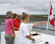
of the boat), and the weather condition. We also include the wind speed
in the weather description and use the wind indicator to do so.
Today's data in on the Daily Data page.
After the day's work is over, Tamara puts the information into an Excel
graph.
Back to Top
Transect
 The
transect method is similar to the residency scan. However, this method
looks at the total number of dolphins in a given area and where they
are located in the river or lake. The residency scan on the other hand,
looks at the frequency of dolphins over a period of time to determine
their movement patterns. The
transect method is similar to the residency scan. However, this method
looks at the total number of dolphins in a given area and where they
are located in the river or lake. The residency scan on the other hand,
looks at the frequency of dolphins over a period of time to determine
their movement patterns.
Tamara always does the transects in the same places and she tries to
do them at the same time of day each time. This way the location and
time of day are consistent in her study.
Unlike the residency scan, the transect requires that the boat continuously
moves from one point in a body of water to another point. As the boat
passes a dolphin, it is counted. Because the boat moves at a speed slightly
faster than dolphins can swim and, because we only count dolphins along
side of us, we never count the same dolphin twice.
This methods allows Tamara to determine if the number of dolphins stays
the same in the area over months and years, and if they have any preference
for where they like to be in the river or lake. For example, do they
prefer to be along the banks or out in the mid channel? She can also
tell if there is a change in the numbers of each species in the area
over time. Are there more or less total dolphins or of just one of the
two species?
We begin the transect by recording the exact position of the boat using
the Global Positing Satellite or GPS as it is called. The GPS also records
the boat speed and the time of day. The wind is recorded with the wind
meter.
Like the residency scan we work in teams of two for a one hour periods.
However, a fifth person is needed for this method. Using the GPS, the
fifth person sits in the middle of the boat deck and calls out the time
and location of the boat each time one of the teams spots a dolphin.
Each team then records that information along with the number of each
species of dolphin spotted on their data sheets.
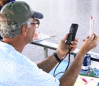
Wind Meter
 It
is important to have some standard measure of the weather when observing
dolphins. When the wind picks up and/or it is raining hard, it becomes
even more difficult too see dolphins. When Tamara looks at our data
sheets,she needs to know if the reason we don't have any dolphins recorded
is because the wind is making it difficult to see them. Or, are there
just not any dolphins in the area. She uses a wind meter to get a reading
of wind speed at the beginning of each observation. Over time she can
compare wind speed to the frequency of dolphin sittings. It
is important to have some standard measure of the weather when observing
dolphins. When the wind picks up and/or it is raining hard, it becomes
even more difficult too see dolphins. When Tamara looks at our data
sheets,she needs to know if the reason we don't have any dolphins recorded
is because the wind is making it difficult to see them. Or, are there
just not any dolphins in the area. She uses a wind meter to get a reading
of wind speed at the beginning of each observation. Over time she can
compare wind speed to the frequency of dolphin sittings.
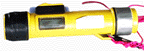
Range Finder Binoculars
Range Finder binoculars are used to determine the width of the river
at any given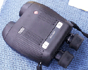 location. The user takes a bearing on one bank by pushing the button
on top of the binoculars which activates a laser. When the button is
pushed again, the finder gives a readout of the distance from where
the user is standing to the bearing on the river bank. We use the range
finder binoculars to determine the width of the body of water we are
in, and to practice judging distances when doing data collection. The
laser beam doesn't accurately read the distance for objects in the water,
so we have to estimate how far the dolphins are from the river banks.
location. The user takes a bearing on one bank by pushing the button
on top of the binoculars which activates a laser. When the button is
pushed again, the finder gives a readout of the distance from where
the user is standing to the bearing on the river bank. We use the range
finder binoculars to determine the width of the body of water we are
in, and to practice judging distances when doing data collection. The
laser beam doesn't accurately read the distance for objects in the water,
so we have to estimate how far the dolphins are from the river banks.
Back to Top
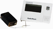
Global Positioning Satellite (GPS)
 A
GPS, as it is called, is a hand held device that communicates with at
least 3 satellites simultaneously to determine an exact location on
the earth in degrees longitude and latitude. It also can record the
boat speed and gives us an accurate reading of the time of day. The
GPS runs off a 12-volt battery or AA batteries. We use it to determine
the location of the dolphins along side the boat in the transect. A
GPS, as it is called, is a hand held device that communicates with at
least 3 satellites simultaneously to determine an exact location on
the earth in degrees longitude and latitude. It also can record the
boat speed and gives us an accurate reading of the time of day. The
GPS runs off a 12-volt battery or AA batteries. We use it to determine
the location of the dolphins along side the boat in the transect.
Back to Top
PH Indicator
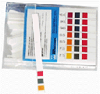 Special
paper is used to measure the degree to which the river water is neutral,
acidic or basic. The paper strip is placed in the water for only a moment
after which it changes color. There is a chart that is used to compare
the new color of the strip to in order to determine the PH. The numbers
on the chart range from 1 to 10 with 1 being the most acidic and 10
being the most basic or alkaline. Special
paper is used to measure the degree to which the river water is neutral,
acidic or basic. The paper strip is placed in the water for only a moment
after which it changes color. There is a chart that is used to compare
the new color of the strip to in order to determine the PH. The numbers
on the chart range from 1 to 10 with 1 being the most acidic and 10
being the most basic or alkaline.
Back to Top
Temperature Probe
 The
temperature probe measures the temperature of the water. A sensor is
lowered into the water and the temperature is read on the meter. Tamara
takes the temperature at both the bottom and surface of the water. The
temperature probe measures the temperature of the water. A sensor is
lowered into the water and the temperature is read on the meter. Tamara
takes the temperature at both the bottom and surface of the water.
Back to Top
Water Depth Indicator
 The
depth indicator measures how deep the water is in meters. It has a sonic
beam which bounces off the bottom of the river and back to the indicator,
measuring the depth at that location. To use the meter, you place the
end of the device on the very tip of the water and push a button which
sends the sonic beam. It must be held vertically to get an accurate
reading. The
depth indicator measures how deep the water is in meters. It has a sonic
beam which bounces off the bottom of the river and back to the indicator,
measuring the depth at that location. To use the meter, you place the
end of the device on the very tip of the water and push a button which
sends the sonic beam. It must be held vertically to get an accurate
reading.
Back to Top
Secchi Disk
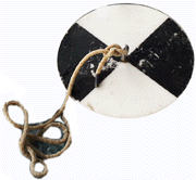 The
secchi disk measures the transparency or clarity of the water. It is
a round disk attached to a long rope. The top of the disk is divided
into four sections. Alternating sections are either white or black.
The rope is marked off in 0.5 meter increments. The disk is lowered
over the side until you can no longer tell the difference between the
black and white sections of the disk. The disk is then taken out of
the water and the water line on the rope indicates the depth to which
the water is transparent. The
secchi disk measures the transparency or clarity of the water. It is
a round disk attached to a long rope. The top of the disk is divided
into four sections. Alternating sections are either white or black.
The rope is marked off in 0.5 meter increments. The disk is lowered
over the side until you can no longer tell the difference between the
black and white sections of the disk. The disk is then taken out of
the water and the water line on the rope indicates the depth to which
the water is transparent.
Back to Top
|


